The Urban Sprawl in Colombia Continues to Expand
By: María Alejandra López Plazas
Photos: Milagro Castro, Archivo DOI https://doi.org/10.12804/dvcn_10336.42588_num7
Economics and Politics

By: María Alejandra López Plazas
Photos: Milagro Castro, Archivo DOI https://doi.org/10.12804/dvcn_10336.42588_num7
A study carried out by an interdisciplinary group of researchers, convened by Fedesarrollo, reveals details of how the growth of Colombian cities has occurred in the last 30 years. Although they grow less quickly than those of the rest of the world, their progress has not always been under the guidelines of territorial planning.
During the last century Colombia has transformed from a rural country to an urban one in an accelerated way. Statistics compiled by the National Administrative Department of Statistics (Dane, by its acronym in Spanish) say that the country's major capitals already exceed 90 percent of the level of urbanization, a pattern that consolidated from the second half of the 20th century to the first two decades of the 21st and point out, in addition, that while in cities such as Bogotá, Medellín, Cali, Barranquilla, the number of homes in urban areas increased by more than 100,000 between the censuses of 2005 and 2018, growth in rural areas was less than 30,000 homes.
Behind these figures are endless stories, such as those of the youngest members of peasant families who decided to leave the farms and go to urban centers in search of new ways to earn a living. There are also grandparents who in their youth released the hoe to participate – without any training – in the construction of the infrastructure that today supports large cities; young people who went to study or entire families who have been displaced as a result of violence.
“Between 2005 and 2018, the level of urbanization of municipalities such as Jamundí, Madrid and Fusagasugá increased by more than seven percentage points, while municipalities such as Mosquera, Facatativá, Piedecuesta, Aguachica, Valledupar, Rionegro and Tumaco increased this indicator by more than two percentage points during the same period,” says Dane in his 2021 report Patterns and Trends of Urban Transition in Colombia.
This is a global trend since the industrial revolution: humanity is piling up in cities. The projection, according toFedesarrollo, is that by 2050 70 percent of the Colombian population will live in urban areas, while in the world the UN forecasts that by 2050 there will be 2.5 billion more people residing in urban areas (today the urban inhabitants are around 4.4 billion, and of them, almost 90 percent will live in cities in Asia and Africa.
This way of inhabiting the planet makes cities play an important role in global warming and climate change, the effects of which are evident and are felt with great harshness at this time. NASA confirmed, for example, that in 2023 the average temperature of the Earth’s surface was the warmest on record.
Cities consume 78 percent of the world's energy and produce more than 60 percent of greenhouse gas (GHG) emissions, according to the United Nations Human Settlements Program (UN-Habitat). Yet they cover less than 2% of the Earth’s surface and are hubs with tight green spaces where life’s turmoil is mostly driven by fossil fuels.
The Special report on the impacts of global warming of the 2018 Intergovernmental Panel on Climate Change (IPCC), warns that to ensure limiting global warming to below the 1.5 °C target set in the Paris Agreement, “a rapid and far-reaching transition is required regarding the use of energy, land, urban spaces and infrastructure, including transportation, buildings and industrial systems.” UN-Habitat recognizes that while cities are already making efforts to transform themselves, decision- makers must adopt more and better policies, the implementation and enforcement of which will effectively combat climate change and the dizzying pace of population growth.
How is Colombia in this picture? In order to evaluate how organized this urban growth has been in the country, an interdisciplinary group of researchers from Fedesarrollo and the Marron Institute of New York University, funded by cooperation resources from the United Kingdom through the UK Partnering for Accelerated Climate Transitions (UK-Pact), carried out a diagnostic review on the implementation of Colombia's territorial and environmental planning policy and its role in the generation of greenhouse gases (GHG).
The results and conclusions were published in a book entitled Diagnosis and recommendations on land use planning in Colombia, in which a series of recommendations for regulatory adjustment to the country's land use planning and the programs that develop it were also compiled.

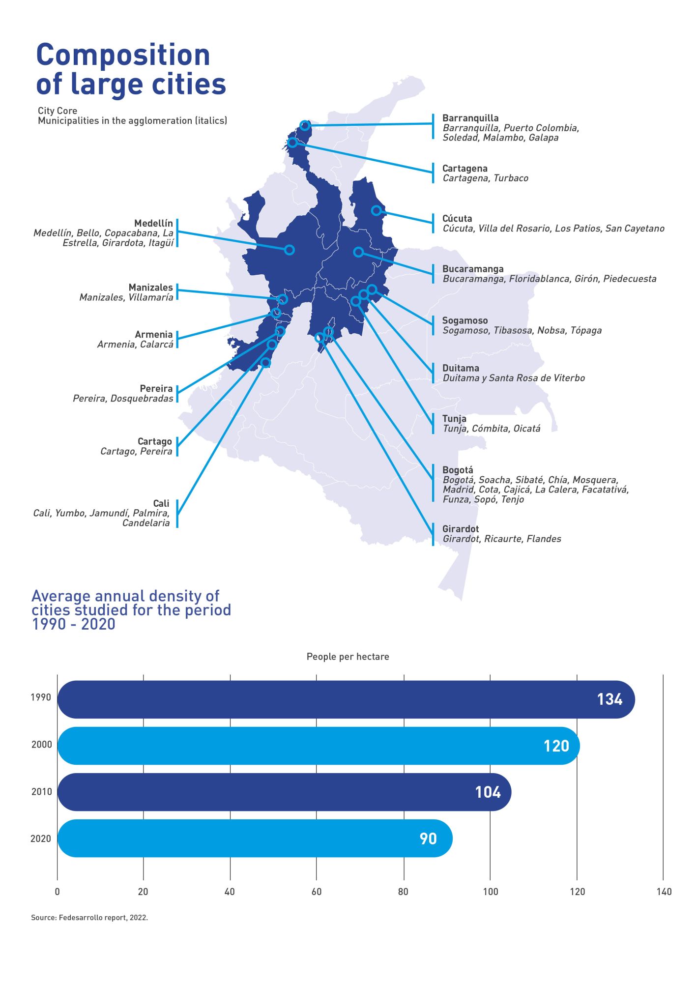
Source: Fedesarrollo report, 2022.
“The big question is, what is the role of land use planning in reducing emissions? We have legislation related to this issue that clearly requires revision in the light of the international commitments that have been acquired,” says professor in the Faculty of Political Sciences, Government and International Relations at Universidad del Rosario Fernando Carriazo, one of the researchers participating in this Fedesarrollo project.
Organized growth?
The researchers analyzed a total of 96 municipalities, mostly with a total population of more than 100 000 inhabitants, although some that do not meet this requirement were included, but have similar dynamics to those cities in issues such as mobility or services. In addition, five municipalities with less than 100 000 inhabitants were studied as case studies for deforestation phenomena.
Among the results of the analysis is, for example, that Colombian cities have had slower than average growth in the rest of the world. In the last 30 years, the country's average population growth rate has been 2.22 percent (in cities with more than 100 000 inhabitants), while worldwide it was 3.42 percent. Regarding to the growth of the urban footprint (the built-up area of a human settlement), while in Colombia it is at 2.98 percent, the global average is at 4.84 percent.
However, although slowly, the urban blob in Colombia continues to expand (according to the 2017 Atlas of Urban Expansion, conducted by the Planning Department and the Marron Institute, Colombia has cities above the average density of the planet). This result is worrying because, as Professor Carriazo explains, a large part of the reasons why cities have a high impact on GHG emissions correspond to the way they are organized and their densification. These two factors influence, on the one hand, the number of kilometers that a person must travel to move from home to work, and vice versa, and, on the other hand, the size of the ecological footprint that could potentially generate models of dispersed and disordered urban expansion.
Densification is a measure that seeks to explain the intensity of the agglomeration of people in a space. In simpler terms, it tells us how we are making better use of space to occupy it with more people in urban areas, without expanding our impact into spaces that had not been inhabited.
According to Fedesarrollo's study, instead of increasing, the density of the cities analyzed has decreased by 33 percent in the last 30 years. This means that while in 1990 Colombian cities had a density in the urban footprint of 134 people per hectare, by 2020 this was 90 people per hectare. However, despite the steady decline in density, Colombian cities are still above the global average of 72 people per hectare.
“When we look at the growth dynamics of the urban blob with data and images, clearly what we can infer is that there has been no densification model for most cities. We are seeing a very accelerated expansion of urban sprawl that leads to very different models from those adopted by cities that aim to be properly densified to reduce the negative environmental impact,” says Professor Carriazo.
In addition, the analysis showed that, on average, for cities with more than 100 000 inhabitants, 74 percent of urban growth occurred on land that was projected for development. That is, of the 132 000 hectares that were added to the urban landscape in these cities, 97 000 are located on urban or sprawling land. Despite this, the experts highlight that an alarming figure of 35 000 hectares is located on land not planned to host this type of development.
“Going forward, the challenges of job creation in Colombian cities, the lack of development of expansion areas and partial renovation plans must be overcome through the consolidation of massive transport systems and the provision of infrastructure and public services that allow the formation of compact and efficient cities. The consolidation of effective coordination mechanisms between municipalities for the achievement of these challenges is also important,” the experts recommend in the technical report.

The problem of deforestation
As a special chapter of the publication, the researchers included a subsection with the analysis of the relationship between deforestation trends and territorial and environmental planning instruments in five municipalities with a high incidence of this phenomenon.
Deforestation, as well as the expansion of the urban patch, is another worrying issue in the fight against climate change: the existence of tropical forests is vital because, among other things, it allows the protection of a vast biodiversity and has a fundamental role in the processes of climate and water regulation and carbon cycles.
The report notes that forest loss rates between 2000 and 2020 were, in terms of total forest area in the five municipalities, 20.6 percent in Cartagena del Chairá, 11.3 percent in Florence, 17.1 percent in San Vicente del Caguán and 18.6 percent in Tumaco. In contrast, researchers estimated a 7.5 percent forest area gain in Yopal.
These figures reflect a characteristic dynamic of these municipalities, since they are places with a significant growth of the agricultural frontier, due, among others, “to the historical processes of colonization, to the presence of extensive livestock, to the convergence of legal and illegal activities fighting for the territory, and to the growth of urban spots.”
As Professor Carriazo explains it, among the findings of the evaluation of deforestation trends in the last 30 years, in addition to agricultural expansion, the conversion of forests to pastures or illicit crops, it was identified that in some cities accelerated urban expansion also begins to have an impact on deforestation. However, the expert notes that in each of the municipalities the problem responds to particular causes that must be analyzed individually.
“We realized, for example, that when the population centers are very small, there can be more deforestation in the vicinity; whereas in large, consolidated cities, deforestation moves to more remote areas because what is near their urban settlements is already deforested. In other distant municipalities, the loss of vegetation cover is also linked to the proximity to water sources, such as rivers, particularly in municipalities on the agricultural border with the Amazon,” adds Carriazo.
The study also highlights that, in general, the environmental management figures associated with the National System of Protected Areas (Sinap, by its acronym in Spanish) have contributed to keeping deforestation at bay, except in the “Second Law Forest Reserves of 1959.” In these areas, aimed at the development of the forest economy, a greater susceptibility to this problem was identified. The experts' recommendation is to strengthen successful strategies and take on conservation models that involve the communities that inhabit these spaces.
Whether from large cities or small urban centers, the challenges to face climate change are large and diverse, and in the face of this the territorial order of the country has fallen short, as the researchers show.

“When we look at the growth dynamics of the urban blob with data and images, clearly what we can infer is that there has been no densification model for most cities. We are seeing a very accelerated expansion of urban sprawl that leads to very different models from those adopted by cities that aim to be adequately densified to reduce the negative environmental impact,” says Professor Fernando Carriazo of Universidad del Rosario.
“The city model cannot be generalized to all departments and cities. There are very large gaps in the capacities to formulate and implement spatial planning (POT), especially between capital cities and smaller urban centers in rural areas. For the most part, municipalities – especially those located in remote areas and with few technical capabilities – have not incorporated key concepts for the conservation of the territory such as the‘main ecological structure’ (a tool for different decision-makers to incorporate and manage the ecosystem dynamics that support the development of territories in the processes of monitoring, management and planning of natural resources and territorial planning”). This also implies that the implementation of POTs in municipalities with low technical capacities is very unorganized and in many cases does not respect the limits of ecosystems,” concludes Carriazo.
Urban development understood from the big cities
Cities with more than 100 000 inhabitants account for 77% of the country's urban population, and of these there are 15 agglomerations that account for 62% (see list below). The individual conditions of these agglomerations are important for understanding how the urban majority of the country lives and what challenges it faces for future planning.
Fedesarrollo's study identified that 25% of Colombia's urban population lives in the "urban footprint of the great Bogotá" (a designation that includes the municipalities of the conurbation), and another 25% lives in the urban footprints of "great Medellín", "great Cali" and "great Barranquilla." This means that 50% of Colombia’s urban population lives in the conurbations of the country’s four largest cities. Therefore, “urban and population growth concentrated in the largest cities is of great impact on the way territorial relations are articulated and, therefore, on the way of understanding and planning sustainable growth.”