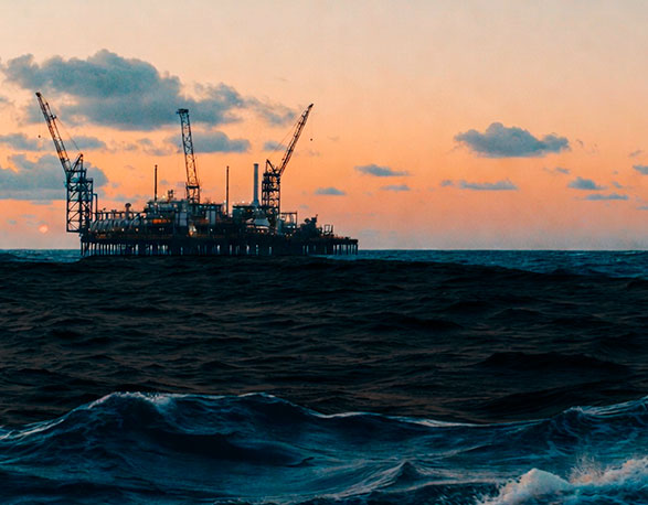
When an oil spill takes place, every second counts as the wind intensifies. Whether they are small spills, such as leaks during refueling or in transport tanks, or large spills caused by collisions, pipeline or platform failures, the consequences for marine ecosystems, national economies, and the community can last for years. At times like these, mathematics can make the difference between disaster and a timely emergency response.
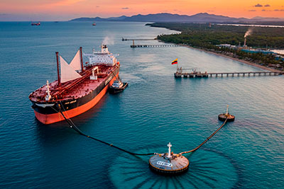
In mid-2014, two accidents that occurred during a crude oil loading operation at the port of Coveñas, in the Gulf of Morrosquillo off the Colombian Caribbean coast, released dozens of barrels of oil, generating an oil slick that posed a threat to coral reefs, mangrove ecosystems, fishing communities, and regional tourism.
These were not the only incidents recorded in the Gulf of Morrosquillo between 1992 and 2021—nine accidents have been reported— but they were the most thoroughly documented. As a result, oceanographers Andrea Devis and Efraín Rodríguez , together with micropaleontologist Daniel Rincón, were able to simulate the resulting disasters and evaluate their potential containment.
For coastal communities that depend on artisanal fishing and tourism, an oil spill represents not only ecological damage but also an immediate economic crisis.
Their suggestion? To mathematically model the behavior of a natural process—specifically, the evolution of an oil slick at sea—using a system of equations solved computationally, in order to assess the model’s accuracy relative to observed real-world events and, in the context of future emergencies, to support the prevention and mitigation of hydrocarbon- related marine accidents
These researchers used OpenOil, an opensource model developed by the Norwegian Meteorological Institute (MET Norway),an institution that uses it for operational contingency, search, and rescue purposes. As an open-source tool, it can be adopted by multiple stakeholders, such as oil companies, port authorities, and maritime authorities.
To operate, the software integrates a set of input variables to generate outputs that define multiple outcome scenarios. Central to this process is the incorporation of diverse datasets—both meteorological and oceanographic— as well as detailed emergency-specific parameters, including water temperature and salinity, wind speed and direction, ocean currents, bathymetry (i.e., the characteristics of the seafloor topography in a given area), the type of hydrocarbon (composition, viscosity, and density), the volume spilled, the precise location of the incident and the depth, among other factors. The reliability of the results is directly proportional to both the quantity and quality of the input data. Based on this information, the software is able to simulate the movement of the oil slick on an hourly basis, predict its spatial configuration and density, and even model the chemical evolution of the hydrocarbon over time.
Case 1
Date: July 20, 2014
Time: 20:30
Location: 9.493° North, 75.776° West, Port of Coveñas, Colombia
Operation: loading of hydrocarbons onto the BT Eurochampion ship by Oleoducto Central SA (Ocensa)
Failure: A sudden increase in tension within the tanker’s mooring system, leading to the release of crude oil from a transfer hose
Consequence: Approximately 69 barrels of hydrocarbons spilled into the sea
In a study conducted in the Gulf of Morrosquillo and funded by Ecopetrol, Devis, Rodríguez, and Rincón employed high-quality global analysis datasets from institutions such as the European Centre for Medium-Range Weather Forecasts (ECMWF) for wind data (ERA-5), and the Copernicus Marine Environment Monitoring Service (CMEMS) for ocean currents and wave conditions (WAVERYS).
Once the data were entered, the model generated simulations whose outputs described both the transport (advection) of the oil slick and the complex weathering processes that alter its physical and chemical properties. The fate of the spilled oil is determined by the interaction of physical factors (currents, waves, and wind), chemical processes (such as oxidation), and biological mechanisms (including biodegradation).
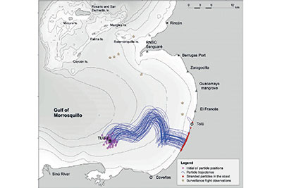
In the first case analyzed, the researchers observed that “the resulting trajectory differs from that recorded by local authorities during surveillance flights conducted on July 21.” According to the model outputs, during the first 24 hours of the incident the oil slick initially moved northward, reaching the waters south of Palma Island, before advection continued southeastward toward the coastline near the El Francés sector.
In their article, Numerical Modeling of Oil Spills in the Gulf of Morrosquillo, Colombian Caribbean, published in the journal Ciencia, Tecnología y Futuro, the authors conclude that “the discrepancies observed between aerial observations and the simulation may be related to the horizontal resolution of the wind and wave forcing fields.” In practical terms, wind and wave data sampled at intervals of 50 to 100 km provide low spatial resolution, as each data point represents a broad area. Consequently, the more detailed and spatially refined the input data, the greater the clarity and reliability of the simulation results. The report further notes that wind intensity may be underestimated in this region.
Case 2
Date: August 21, 2014
Time: 22:00
Location: 9.496° North; 75.737° West, Port of Coveñas, Colombia
Operation: loading of hydrocarbons onto the Energy Challenger ship by Ecopetrol
Failure: A crack in the ballast water system, allowing the release of hydrocarbon-contaminated ballast water.
Consequence: Approximately 50 barrels of hydrocarbons spilled into the sea
Case 1 The oil spill of July 20 originated at the location indicated by the purple markers, with most of the slick drifting northward (yellow markers) toward the vicinity of Isla Palma. By contrast, the simulation—represented by the blue trajectories—projected transport of the slick toward Tolú.
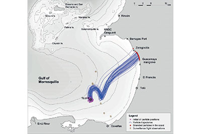
In the second case, the model showed greater agreement with observed conditions: “part of the simulated trajectories coincide with reports from local authorities, who monitored the oil slick via aerial surveillance on August 22, as well as with information from the tourism sector, which documented beach contamination on August 23.” According to the authors, the causes of the discrepancies between the simulated results and the observed spill behavior are the same as those identified in the first incident.
Case 2 The oil spill of August 21 originated at the location indicated by the purple markers and moved toward the central coast of the Gulf, eventually reaching the El Francés sector and the beaches of Guacamaya and Zaragocilla. In this case, the simulated model—represented by the blue trajectories—provided a closer approximation to the observed events.
The model illustrated, for example, how the combination of strong winds and elevated temperatures accelerates crude oil evaporation, while wave action promotes emulsification, a process in which oil mixes with water to form a viscous substance commonly referred to as “chocolate mousse.”
In both incidents, the oil spills (identified as Vasconia, after the name of the collection station in Puerto Boyacá) ultimately affected the beaches of the Gulf, where tar balls were detected as a result of hydrocarbon weathering. As the oil sinks, it comes into contact with seabed sand and sediments, forming dark nodules that, although easier to collect than oil dispersed in the water column, reflect a delayed response to the emergency.
“This work provides a preventive tool that also serves as a rapid-response mechanism,” explains Devis. “If a spill were to occur tomorrow, the model could indicate within an hour where the oil is likely to move and which areas should be prioritized for closure or protection, provided that the actors involved in hydrocarbon management have these systems in place.” She further underscores the importance of maritime authorities and oil companies maintaining continuous meteorological and oceanographic monitoring to properly assess marine and coastal risks.
A real risk for the Caribbean
Although Colombia does not currently extract oil offshore, the potential risk remains. Maritime terminals where oil tankers are loaded—such as Coveñas and Cartagena—are hubs of intense crude oil transfer activity.
Andrea Devis from the Universidad del Rosario explains: “If a spill were to occur tomorrow, the model could indicate within an hour where the oil is likely to move and which areas should be prioritized for closure or protection, provided that the actors involved in hydrocarbon management have these systems in place.” She further underscores the importance of maritime authorities and oil companies maintaining continuous meteorological and oceanographic monitoring to properly assess marine and coastal risks.
As a result of heavy tanker traffic, including tanker vessels supplying fuel to ships in transit, the Caribbean region is classified as a high-risk area for oil pollution.Therefore, approximately83% of the Caribbean Sea is considered under threat, particularly the maritime corridor connecting Colombia and Jamaica, which forms part of major international oil routes.
For coastal communities that depend on artisanal fishing and tourism, an oil spill represents not only ecological damage but also an immediate economic crisis. “When those tar balls reached the beaches, closures were imposed, jobs were lost, and severe social impacts followed,” recalls Devis. “What is most concerning is that the response was delayed; had an operational model been available, those slicks likely would not have reached the coast.”
From algorithms to action
Devis emphasizes that Colombia’s General Maritime Directorate (Dimar), along with all oil companies operating in marine environments, should maintain dedicated meteorological and oceanographic units, implement mathematical modeling tools to assess marine and coastal risks, and share this information with port authorities in a manner comparable to weather forecasting systems.
“The technology exists, but institutional will and coordination are lacking,” Devis states. “When applied proactively, these models can protect ecosystems and resources before disasters occur. International companies do not deploy these systems in Colombia simply because they are not required to do so.”
Whether resulting from minor spills, major releases, or failures in pipelines or offshore platforms, oil spill events can have longlasting consequences for marine ecosystems, national economies and the social fabric of affected communities.
Experiences from other countries reinforce this position. In the United States, the National Oceanic and Atmospheric Administration (NOAA) operates the GNOME system to predict oil spill trajectories and support emergency response decisions. Similarly, the Norwegian Meteorological Institute runs the OpenDrift system on a daily basis to prevent and mitigate accidents in the North Sea.
The marine environment is dynamic and allows no delay. “Colombia lags significantly in the regulation of marine issues,” the oceanographer concludes. “Only recently were the terms of reference for environmental impact assessments of offshore hydrocarbon operations issued, making the use of mathematical modeling systems mandatory.” Understanding the sea is essential—but safeguarding it is even more imperative.
“Without real-time information, reliable predictions of spill behavior are not possible.”
Mathematical modeling of marine oil spills requires far more than robust algorithms; it is critically dependent on accurate, real-time hydrodynamic, atmospheric, and oceanographic forecasts. In this regard, oceanographer and mathematician Serguei Lonin emphasizes that the primary challenge lies not in the spill model itself, but in the availability of basic, detailed, and accurate data required to drive it.
“To achieve reliable predictions, it is necessary to employ a coupled atmospheric–oceanic model with very high spatial resolution,” explains Lonin, who served for a decade as a scientific advisor to the Center for Oceanographic and Hydrographic Research of Colombia’s General Maritime Directorate (Dimar). “In 1994, while I was working at the Academy of Sciences in Ukraine, Dimar invited me to Colombia specifically to develop models for predicting oil spills in Cartagena Bay, the Gulf of Morrosquillo, and Pozos Colorados in Santa Marta,” adds Lonin, who is currently the director of the Oceanology Research Group at the Almirante Padilla Naval Academy.
Lonin notes that global systems, such as those developed under the European Copernicusprogram, typically operate at spatial resolutions of 9 to 27 km. However, to capture short-lived yet decisive phenomena—such as gales, which are frequent along the Caribbean coast and can significantly alter the trajectory of an oil slick—resolutions on the order of 100 m are required. In the absence of such detailed information, models can only provide approximate simulations or produce results that fail to align with observed spill trajectories.
With respect to the role of artificial intelligence, the oceanographer acknowledges its considerable potential, while emphasizing that its effectiveness remains constrained by the limited availability of reliable data. “Neural networks,” he explains, “learn from examples, and in Colombia, records of oil spills are scarce and highly heterogeneous. The appropriate strategy, therefore, is to first strengthen deterministic models—such as OpenOil—to generate millions of hypothetical scenarios that can serve as training data for artificial intelligence systems.” Under such conditions, AI would be capable of producing forecasts within seconds, albeit always within probabilistic margins. In the interim, the priority remains the establishment of continuous, 24/7 meteorological and oceanographic monitoring, combining local observation stations with high-resolution models. “Only then,” Lonin concludes, “will it be possible to realistically predict the behavior of an oil spill and mitigate its impact before it reaches the coast.”